The apostle Paul is one of the most important figures in the New Testament, known for his missionary work, his writings, and his influence on the early Christian church. Paul's journeys are described in detail in the book of Acts, and Bible charts can help us visualize and understand the geographic and historical context of his travels. Here are some examples of how Bible charts can help us map Paul's journeys.
- Paul's First Journey: This chart shows the cities and regions that Paul visited on his first journey, including Antioch, Cyprus, Pisidian Antioch, Iconium, Lystra, and Derbe.
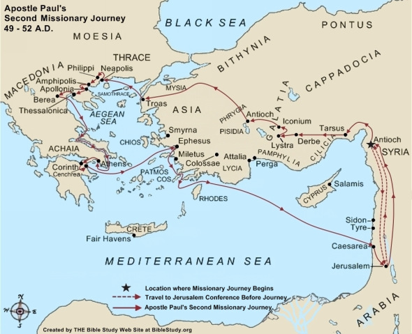
- Paul's Second Journey: This chart shows the cities and regions that Paul visited on his second journey, including Philippi, Thessalonica, Berea, Athens, and Corinth.
- Paul's Third Journey: This chart shows the cities and regions that Paul visited on his third journey, including Ephesus, Troas, Philippi, Corinth, and Jerusalem.
- Paul's Voyage to Rome: This chart shows the route that Paul took on his journey to Rome, including his shipwreck on the island of Malta.
- The Spread of Christianity: This map shows the spread of Christianity throughout the Roman Empire during the first century, highlighting the role of Paul and other early missionaries.
By using Bible charts to map Paul's journeys, we can gain a deeper understanding of the historical and geographic context of his missionary work, and appreciate the challenges and opportunities that he faced as he spread the message of the Gospel throughout the ancient world. These charts can also inspire us to follow in Paul's footsteps, by sharing our faith with others and seeking to build up the church in our own time and place.